Amir Dotan: Promoting and Sharing Stoke Newington’s Rich History Since 2012
Then & Now – Animations
Following the success of my photo mashup project, I began exploring other ways to use technology for ‘now and then’ comparisons. This led to the creation of a new series of animations, where historical photographs gradually transition into their modern-day counterparts. These animations offer a dynamic way to visually reveal the changes in Stoke Newington, allowing viewers to witness the transformation of the area frame by frame.
Stoke Newington’s streets have seen significant transformations, including the Victorian housing boom of the 1860s–90s, housing redevelopments in the 1930s, 1960s, and 1970s, as well as post-war reconstruction following WW2 bomb damage. The 20th-century changes, including road widening in the 1920s and 1930s, often erased entire blocks of Victorian and earlier structures. For many, these shifts can make it difficult to identify or imagine where certain historical moments took place.
These animations build on my previous mashup work by offering a new way to explore Stoke Newington’s history.
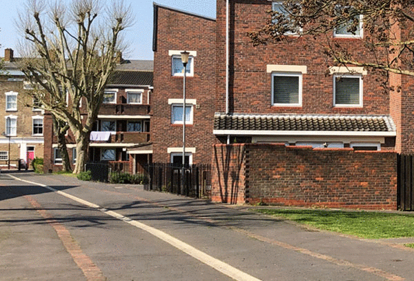
Victorian Road
Victorian Road looking west towards Nevill Road before Yorkshire South Estate was built on the site. The Prince Albert pub on the right.
Clissold Park Bowling Green
The Clissold Park Bowling Green
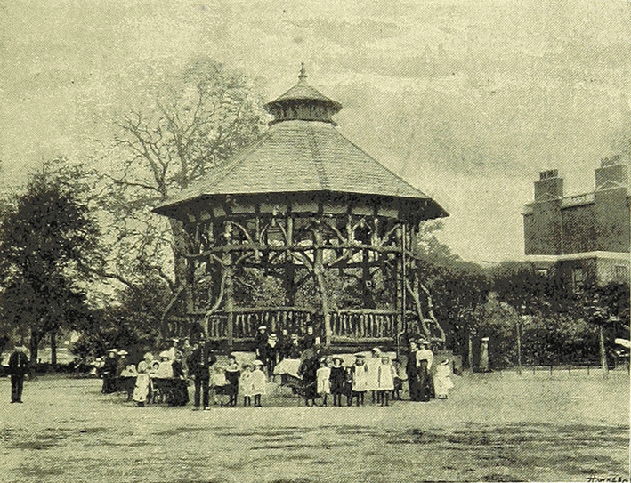
Clissold Park Bandstand
The Clissold Park bandstand. The ‘rustic’ bandstand was erected in 1893 next to Clissold House, four years after the park opened. It was altered in 1912. It was removed in 1965.
Kennaway Hall
Kennaway Hall (formerly The Willows), Paradise Row, Church Street. Built for George William Alexander; A Quaker and founding treasurer of the British and Foreign Anti-Slavery Society in 1839. It was demolished in 1953.
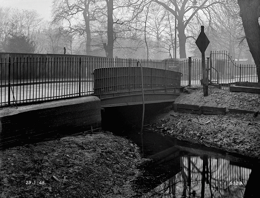
Paradise Bridge
Paradise Bridge in Stoke Newington Church St in 1948 just before it was demolished. This is where the New River exited Clissold Park towards Aden Terrace, Petherton Rd towards Islington. It now ends in the East Reservoir.
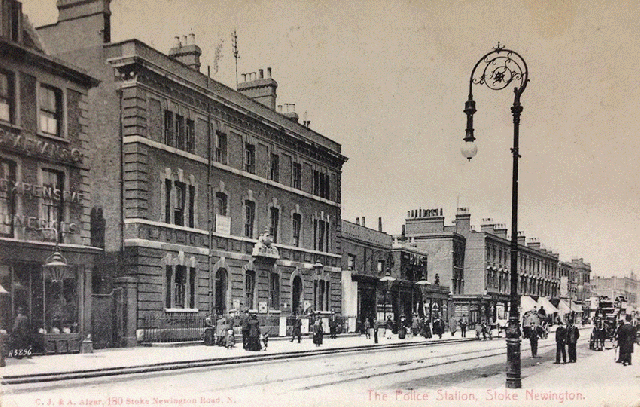
Stoke Newington Police Station
Stoke Newington’s Victorian Police Station (built 1868) next to the Victoria pub (1866-1996). The Police Station was rebuilt and enlarged in 1990.
Denman House
Denman House was built in 1937 on the site of small houses in Barn Street, Lordship Terrace and Lordship Road that were declared a ‘Slum Clearance Area’. There were 7 such slum clearance areas in Stoke Newington.
Carysfort Road
Carysfort Road
Nevill Road
1929 – John Wesley Lotts bakery, 33 Nevill Road
Nevill Road
A. Pagliaro 11 Nevill Road. One of 20 shops along the street that were converted to flats over the years.
Holland House (Also known as Olympic House)
Holland House, 42 Newington Green. Demolished in 1961. At one time it had become the OXO factory. The present building was built in the 1990s.
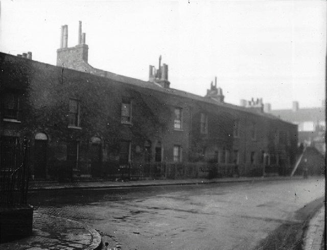
Yoakley Road
Early Victorian houses in Yoakley Rd (formerly Park St) in 1968 built c. 1845 where the Levy Memorial Garden is now near Church Street. Later renamed after Michael Yoakley. 10 houses built on the road in the early 19th century were financed by Michael Yoakley charity.
Clissold Road Swimming Bath
The Public Swimming Bath in Clissold Road. Designed by Hobden and Porri who also designed the Simpsons factory in Stoke Newington Road (now Beyond Retro) and the Church St WW1 Memorial Hall. Opened in 1930. Demolished in 1997.
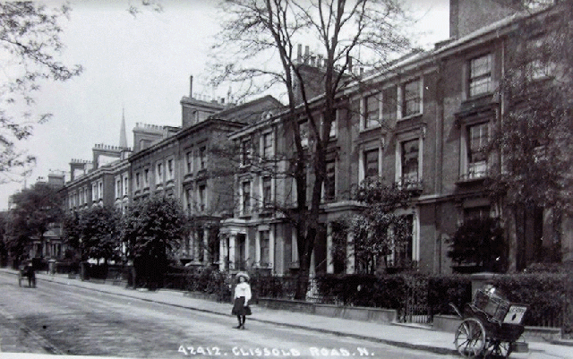
Clissold Road
Clissold Road. Built in the 1850s. The houses on the left were demolished in the late 1960’s to make way for Clissold Park School which is now known as Stoke Newington School & Sixth Form
Newington Green
The Stoke Newington end of Newington Green. The Georgian houses on the left were pulled down when Albion Road was widened and a bank was built on the site. The former Barclays Bank building is now flats.
Stoke Newington Church Street
105-113 Stoke Newington Church St c.1920. William Ernest Farrance took over the beer shop at no. 105, which by the mid-1950s became a pub called The Horse and Groom. That was the name of the beer shop in the 1870s. Auld Shillelagh since 1991.
109 -111 Stoke Newington Church Street
109-111 Stoke Newington Church Street in 1844 and today. Shop extensions were added to the ground floor in the mid 19th century.
106 Stoke Newington Church Street (old numbering)
106 Church St (old numbering). Built c.1755 and demolished in 1931. Home of John Aikin, doctor and writer. It was St Mary’s day nursery 1906-18.
Stoke Newington Church Street
158-64 Stoke Newington Church St in 1973
Stoke Newington Church Street
Stoke Newington Church St corner of Yoakley Road (formerly Park Street).
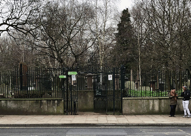
Abney House
An iron gateway is all that remains of Abney House (1700-1843). Once the grand manorial estate and home of Sir Thomas and Mary Lady Abney. It’s now the Church St entrance to Abney Park Cemetery.
Stoke Newington High Street
180 Stoke Newington High Street.
187 Stoke Newington High Street
187 Stoke Newington High Street, built in 1714, was rebuilt in 1983 with only the original facade surviving, after years of standing derelict. Now YumYum restaurant.
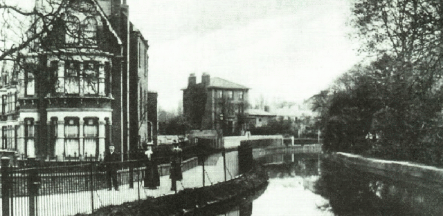
Aden Terrace
A view of Aden Terrace and the New River from Park Lane Bridge in Park Lane (later renamed Clissold Crescent). This section of the New River was filled in in 1947. The allotments were created that same year.
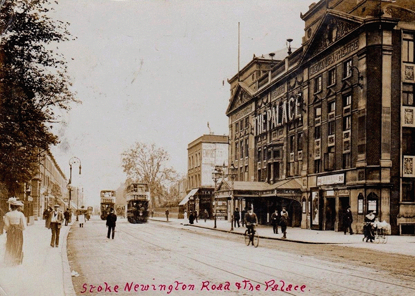
Alexandra Theatre
The Alexandra Theatre, 65-7 Stoke Newington Rd. Designed by Frank Matcham (1854-1920). Built in 1897, closed in 1950, derelict till the early 1960s when it was pulled down and Alexandra Court housing block was built on the site.
Alexandra Theatre
The Alexandra Theatre, 65-7 Stoke Newington Rd. Designed by Frank Matcham (1854-1920). Built in 1897, closed in 1950, derelict till the early 1960s when it was pulled down and Alexandra Court housing block was built on the site.
Coliseum Cinema
The Coliseum Cinema, 31 Stoke Newington Road. Opened 1913, closed 1972. Damaged by fire in 1992. Pulled down in 2001.
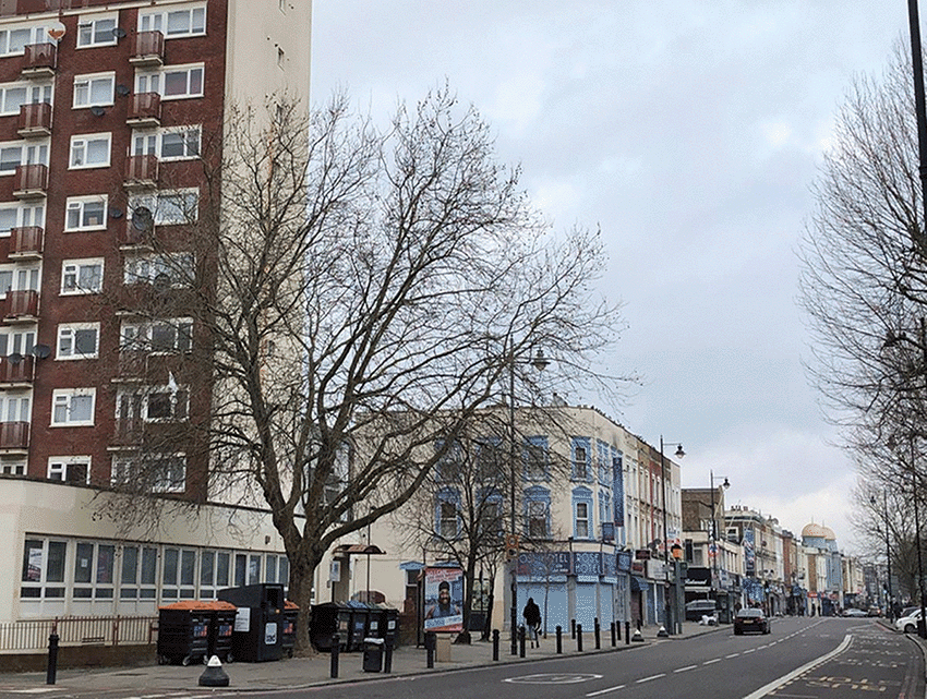
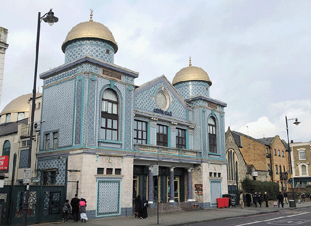
Astra Cinema
The former Astra Cinema (formerly Apollo Picture House, The Ambassador), 117 Stoke Newington Road. Opened 1913 closed 1983. Now Aziziye Mosque and Community Centre.
The Black Bull
The Black Bull pub, 192 Stoke Newington High Street.
The Nevill
The Neville Arms, 31 Nevill Road. Now residential property. One of 20 pubs within the boundaries of the former Metropolitan Borough of Stoke Newington which closed down over the decades. The are 17 pubs active today.
The White Hart
The White Hart pub, 69 Stoke Newington High Street. Note the Saloon Bar entrance on the left and Private Bar entrance on the right.
The Red Lion
The Red Lion in 1890. Originally two separate houses, the pub was first recorded in 1697. It was pulled down in 1924 and rebuilt when Lordship Road was widened.
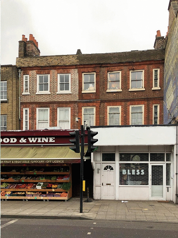
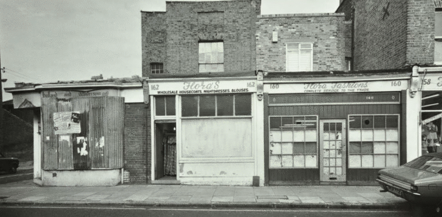
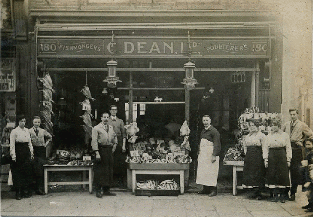
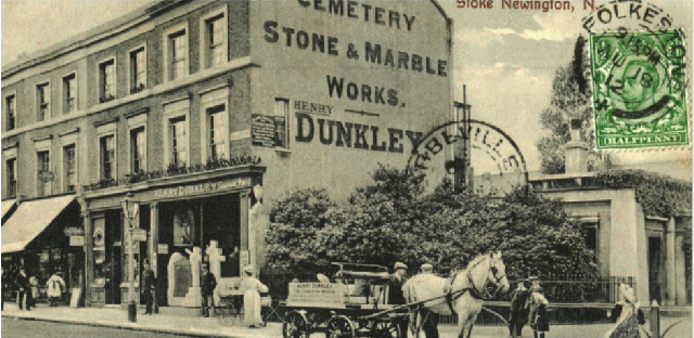
Stoke Newington High Street
Henry Dunkley, Cemetery Stone & Marble Works, 217 Stoke Newington High Street
St. Faith’s Church
St Faith’s Church on the corner of Londesborough Rd and Knebworth Rd. It was severely damaged in WW2 and never rebuilt. St Faith Parish was merged with St Matthias in the 1950s along with All Saints Parish.
Devonshire Square Church
Devonshire Square Baptist Church, Stoke Newington Rd/Walford Rd. Damaged during WW2. The building was restored, though without the spire. New church was built and later demolished. Only the small section on the left remains today. Devonshire House was built on the main site.
West Hackney Church
West Hackney Church, Stoke Newington Road/Amhurst Road. Built in 1824, this grand church was hit with high explosive bombs on 18/19th Sep 1940. A new church was built on the site c.1960.
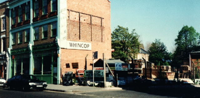
Stoke Newington Church Street
Whincop Timber Merchants was a feature of Church Street’s commercial landscape for 130 years till the late 1990s.