Skip to content

Stoke Newington History

Amir Dotan: Researching, Preserving and Sharing Stoke Newington’s History Since 2012

  • Home
  • About
  • Contact
  • Talks & Events
    • Stoke Newington History Talks
    • Talks by Topic
    • Talks by Event
  • Research
    • Church Street: History of Every Shop
      • Church St Property Survey (1847–Present)
      • Church Street Shop History (Book)
      • Shop Histories Display
      • Annual Shopfront Survey
      • Church Street Project Site
      • Shop Time Machine
      • Independents vs Chains Analysis
    • Oral Histories
    • Clissold Park Preservation Campaign
      • The Clissold Park Campaign Archive
      • Transcribing the 1886 Petition to Save Clissold Park
    • Survey of Stoke Newington’s Heritage Street Signs
    • Stoke Newington Coalhole Covers
  • Heritage Advocacy
    • Street Sign Restoration
    • T. J. Electrics Shop Sign Rescue
    • Joseph Beck Plaque Installation
    • Foundation Stone Restoration
    • Hawksley Court Plaque Replacement
    • Victorian Tile Preservation
  • Projects
    • Local History Drop-In Sessions
    • Self-Guided Walks
      • Stoke Newington’s Lost Pubs Walk
      • Stoke Newington Boundary Walk
    • Then & Now
      • Slider
      • Photo Mashups
      • Animations
    • Short-form history videos (Reels)
    • Stoke Newington’s Lonely Hearts Club Band Poster
  • Press & Appearances
  • Updates

Illustrated Map of Clissold Park

On June 30, 2018January 3, 2025 By amirdIn Uncategorized

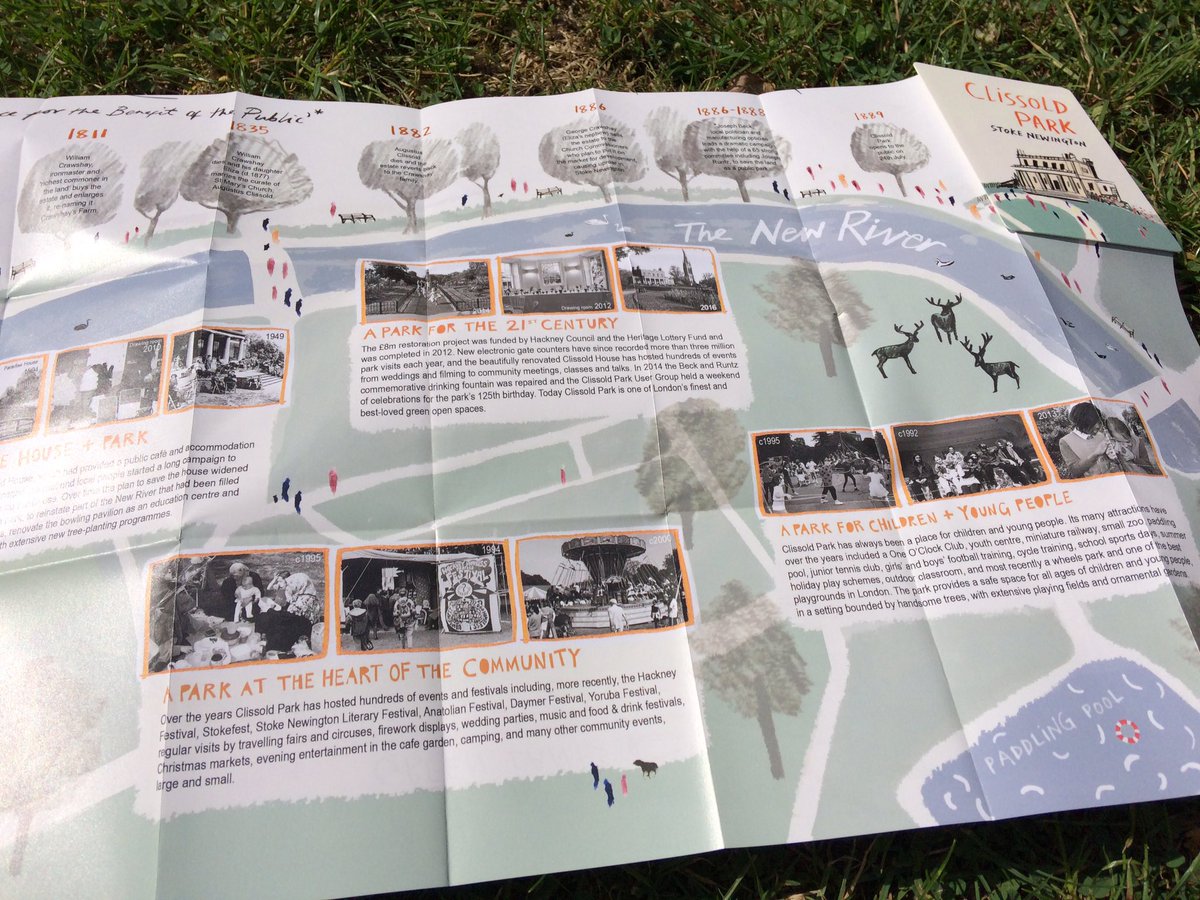
I contributed the history section to a beautifully illustrated map of Clissold Park. The map was produced by the Clissold Park User Group and illustrated by Anna Hymas. You can buy the map in Clissold House cafe.

DFP-xLfWAAAQqn3

Share this:

  • Share on X (Opens in new window) X
  • Share on Facebook (Opens in new window) Facebook
Like Loading...

Related

Post navigation

Previous

Stoke Newington’s Lonely Hearts Club Band Poster

Next

22.05.2017 – Stoke Newington History Talks #3: Images from the 70s-80s, Church St property survey, Garden City Movement

Social

  • Facebook
  • Instagram
  • YouTube
  • Flickr
Whincop & Son, builders’ merchants and timber yard, traded from 32–40 Stoke Newington Church Street from 1867 until 1998. A small stone tablet on the northern boundary wall of the Lordship Terrace and Queen Elizabeth’s Walk Estate is quietly disappearing. Something is slowly emerging from beneath the paint at 82 Mountgrove Road. One of the details that often goes unnoticed on Victorian houses is hidden above the front door. Health of Stoke Newington in 1896 Clissold House in 1876, when the house and its surrounding grounds were still part of a private estate. This 1930s ‘Borough of Stoke Newington’ street sign on Green Lanes, near Endymion Road, marks the northernmost point of the former Metropolitan Borough of Stoke Newington, which existed from 1900 to 1965. The commemorative fountain in Clissold Park is dedicated to Joseph Beck and John Runtz; the chief campaigners who saved the park from development in the mid 1880s. Erected in 1890, paid for by donations from local residents. Both Joseph Beck and John Runtz died in 1891. The tram shelter in Seven Sisters Road, Stoke Newington looking west with Finsbury Park in the background. The steps linked it to Manor House Tube Station. A view of the New River from Woodberry Down Bridge, Stoke Newington. The East Reservoir is on the left. The bridge is still there and can be accessed from Bethune Road or Newnton Close. The view has changed but the New River is still there since it opened in 1613. St Mary’s new Church, Stoke Newington. Built 1855-8. Designed by Sir George Gilbert Scott. The steeple, designed by Scott’s son John Oldrid Scott, was only added in 1890. Built on the site of the old wooden Rectory House. 163 Stoke Newington Church Street, corner of Woodlea Road. Walford Road Synagogue began as the New Dalston Synagogue in 1912, initially located at Blanche Hall, a former events venue at 99 Belgrade Road, on the corner of Wordsworth Road near St. Matthias Church. Hawksley Court Garage, Albion Road (Photo by Terry Gilley). Then & Now: Stoke Newington High Street.
  • My Talks
  • Paradise Row: A Corner of Old Stoke Newington (Slides, Recording)
  • Ghost Shop Signs: Accidental Finds, Briefly Revealing Lost Shops (Slides, Recording)
  • Look up, Look down: Spotting local history everywhere (Slides, Recording)
  • Reconstruct, Restore, Reimagine: New Perspectives on Stoke Newington’s History Through AI (Slides, Recording)
  • The Battle of Belgrade Road: A WW1 Street Renaming Saga (Slides, Recording)
  • Pints, Partitions and Rebuild - The Red Lion’s 300-Year History (Slides, Recording)
  • From Houses or Votes to a Public Park - The Creation of Butterfield Green (Slides, Recording)
  • 1930s Stoke Newington - Rediscovering a Decade of Profound Change (Slides, Recording)
  • Bidding on the Past – Unearthing Stoke Newington’s history through eBay finds (Slides, Recording)
  • The History of Stoke Newington Street Names (Slides, Recording)
  • Stoke Newington’s Lost Pubs and Ghost Cinemas – A Visual Journey (Slides, Recording)
  • How Clissold Park was saved by the public for the public (Slides, Recording)
  • A Glimpse into Hackney Archives' photos of Stoke Newington (Recording)
  • Lost in the Shed – Unearthing a Treasure Trove of Printing Material from the 1930s-50s (Slides, Recording)
  • The Segregated Pub – A History of Class and Gender-based Drinking (Slides, Recording)
  • Back to the Local...A Stoke Newington perspective (Slides, Recording)
  • The architects who built Stoke Newington (Recording)
  • Come Fly With Me – Exploring old aerial photos of Stoke Newington (Slides, Recording)
  • Stoke Newington’s seven long-lost cinemas (Slides)
  • A Visual History of Stoke Newington Church Street (Slides)
  • Photos from the Hackney Archives (Slides)
  • The evolution of Stoke Newington Church Street 1847-2017 (Slides)
  • Stoke Newington pubs – Converted. Demolished. Rebuilt. (Slides)
  • Stoke Newington’s lost pubs (Slides)
  • 130 years of Clissold Park (Slides)
  • Stoke Newington churches (Slides)
  • Before the building boom: Exploring the 1846 map (Slides)
  • On Maps and in Minds: The Boundaries of Stoke Newington (Slides)

Do you have anything to share?

I’m always very interested to hear from people who have old photos of Stoke Newington and anything else relevant to the area’s past such as home movies, documents etc.

Click here to get in touch if you would like to share any items you have.

Book Me as a Guest Speaker

I give talks about various Stoke Newington history related topics such as the campaign to save Clissold Park, pubs, the evolution of Church Street since 1847 and more.

Click here to get in touch if you would like to discuss a potential speaking engagement.

Stoke Newington History Talks

I run a free quarterly event called Stoke Newington History Talks where I’m joined by two different speakers each time.

Click here to get in touch if you would like to be a guest speaker at a future event. Subscribe to the mailing list to be notified about upcoming events.

Blog at WordPress.com.
  • Reblog
  • Subscribe Subscribed
    • Stoke Newington History
    • Already have a WordPress.com account? Log in now.
    • Stoke Newington History
    • Subscribe Subscribed
    • Sign up
    • Log in
    • Copy shortlink
    • Report this content
    • View post in Reader
    • Manage subscriptions
    • Collapse this bar

Loading Comments...

    %d