Skip to content

Stoke Newington History

Amir Dotan: Researching, Preserving and Sharing Stoke Newington’s History Since 2012

  • Home
  • About
  • Contact
  • Talks & Events
    • Stoke Newington History Talks
    • Talks by Topic
    • Talks by Event
  • Research
    • Church Street: History of Every Shop
      • Church St Property Survey (1847–Present)
      • Church Street Shop History (Book)
      • Shop Histories Display
      • Annual Shopfront Survey
      • Church Street Project Site
      • Shop Time Machine
      • Independents vs Chains Analysis
    • Oral Histories
    • Clissold Park Preservation Campaign
      • The Clissold Park Campaign Archive
      • Transcribing the 1886 Petition to Save Clissold Park
    • Survey of Stoke Newington’s Heritage Street Signs
    • Stoke Newington Coalhole Covers
  • Heritage Advocacy
    • Street Sign Restoration
    • T. J. Electrics Shop Sign Rescue
    • Joseph Beck Plaque Installation
    • Foundation Stone Restoration
    • Hawksley Court Plaque Replacement
    • Victorian Tile Preservation
  • Projects
    • Local History Drop-In Sessions
    • Self-Guided Walks
      • Stoke Newington’s Lost Pubs Walk
      • Stoke Newington Boundary Walk
    • Then & Now
      • Slider
      • Photo Mashups
      • Animations
    • Short-form history videos (Reels)
    • Stoke Newington’s Lonely Hearts Club Band Poster
  • Press & Appearances
  • Updates

IMG_7108

On July 15, 2018 By amird

Post navigation

Previous

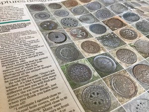
12.07.2018 Hackney Gazette: Stoke Newington Historian Documents the Fascinating Designs of Victorian Coal Hole Covers

Social

  • Facebook
  • Instagram
  • YouTube
  • Flickr
29.08.1912 — William Booth’s funeral outside Abney Park Cemetery, Stoke Newington. Paradise Bridge carried Stoke Newington Church Street over the New River, near the present-day 393 bus stops, near Clissold Crescent. Stoke Newington Church St c. 1925. Abney Chapel on the right where Townsend Court flats were built in 2000 on the site of a postwar church. Aden Grove, Stoke Newington. All Saints Church on the right. It was demolished in the 1950s when the parishes of All Saints and St Faith’s were merged with St Matthias. Note the pump on the left filling a water-cart used in dry days to wet the roads when they were dusty. Stoke Newington Church Street at the corner of Yoakley Road. The shop on the right was later converted into a flat. In 1925, public baths were built on the site of the building across Yoakley Road. After the baths closed, the building was used by the Sea Cadets for many years. Today, the former Sea Cadets building serves as a nursery. Lordship Road looking south and the Engine House in the East Reservoir, Stoke Newington. The Engine House was built in 1833. It was demolished in 1902. The Albion pub, 2 Clissold Road. The building was converted to a residential property when the pub closed. A view from Green Lanes of Petherton Road. The east side (left) between Green Lanes and Leconfield Road was in the Borough of Stoke Newington. The New River ran in the middle of the road and was culverted in 1860. The New River was shortened in 1946 and ends in the East Reservoir In Bethune Road. West Hackney Church (Stoke Newington Rd/Amhurst Rd). Built between 1821-24. Designed by Sir Robert Smirke who also designed the British Museum. It was hit with high explosive bombs on 18/19th Sep 1940 and was destroyed. A new church was built on the site in 1960. The Falcon Tavern, 151 Stoke Newington Church Street, c. 1850. It stood almost opposite Barn Street, next to the site now occupied by Nando’s. The bandstand next to Clissold House in Clissold Park. Derelict 187 Stoke Newington High Street in the 1970s. Built in 1712. Rebuilt in 1983 with only the original facade being retained. Today it’s a restaurant and flats. The Borough of Stoke Newington World War I Memorial Hall opened on this day 103 years ago, on 14 June 1923. The Allen Arms, 8 Allen Road, next to Butterfield Green. It’s a residential property now. An old “Cycling Prohibited By Order” sign in Kynaston Avenue near Stoke Newington High Street. There are only five other surviving signs of this type, which I estimate date back to the 1950s.
  • My Talks
  • Paradise Row: A Corner of Old Stoke Newington (Slides, Recording)
  • Ghost Shop Signs: Accidental Finds, Briefly Revealing Lost Shops (Slides, Recording)
  • Look up, Look down: Spotting local history everywhere (Slides, Recording)
  • Reconstruct, Restore, Reimagine: New Perspectives on Stoke Newington’s History Through AI (Slides, Recording)
  • The Battle of Belgrade Road: A WW1 Street Renaming Saga (Slides, Recording)
  • Pints, Partitions and Rebuild - The Red Lion’s 300-Year History (Slides, Recording)
  • From Houses or Votes to a Public Park - The Creation of Butterfield Green (Slides, Recording)
  • 1930s Stoke Newington - Rediscovering a Decade of Profound Change (Slides, Recording)
  • Bidding on the Past – Unearthing Stoke Newington’s history through eBay finds (Slides, Recording)
  • The History of Stoke Newington Street Names (Slides, Recording)
  • Stoke Newington’s Lost Pubs and Ghost Cinemas – A Visual Journey (Slides, Recording)
  • How Clissold Park was saved by the public for the public (Slides, Recording)
  • A Glimpse into Hackney Archives' photos of Stoke Newington (Recording)
  • Lost in the Shed – Unearthing a Treasure Trove of Printing Material from the 1930s-50s (Slides, Recording)
  • The Segregated Pub – A History of Class and Gender-based Drinking (Slides, Recording)
  • Back to the Local...A Stoke Newington perspective (Slides, Recording)
  • The architects who built Stoke Newington (Recording)
  • Come Fly With Me – Exploring old aerial photos of Stoke Newington (Slides, Recording)
  • Stoke Newington’s seven long-lost cinemas (Slides)
  • A Visual History of Stoke Newington Church Street (Slides)
  • Photos from the Hackney Archives (Slides)
  • The evolution of Stoke Newington Church Street 1847-2017 (Slides)
  • Stoke Newington pubs – Converted. Demolished. Rebuilt. (Slides)
  • Stoke Newington’s lost pubs (Slides)
  • 130 years of Clissold Park (Slides)
  • Stoke Newington churches (Slides)
  • Before the building boom: Exploring the 1846 map (Slides)
  • On Maps and in Minds: The Boundaries of Stoke Newington (Slides)

Do you have anything to share?

I’m always very interested to hear from people who have old photos of Stoke Newington and anything else relevant to the area’s past such as home movies, documents etc.

Click here to get in touch if you would like to share any items you have.

Book Me as a Guest Speaker

I give talks about various Stoke Newington history related topics such as the campaign to save Clissold Park, pubs, the evolution of Church Street since 1847 and more.

Click here to get in touch if you would like to discuss a potential speaking engagement.

Stoke Newington History Talks

I run a free quarterly event called Stoke Newington History Talks where I’m joined by two different speakers each time.

Click here to get in touch if you would like to be a guest speaker at a future event. Subscribe to the mailing list to be notified about upcoming events.

Blog at WordPress.com.
  • Subscribe Subscribed
    • Stoke Newington History
    • Already have a WordPress.com account? Log in now.
    • Stoke Newington History
    • Subscribe Subscribed
    • Sign up
    • Log in
    • Copy shortlink
    • Report this content
    • View post in Reader
    • Manage subscriptions
    • Collapse this bar